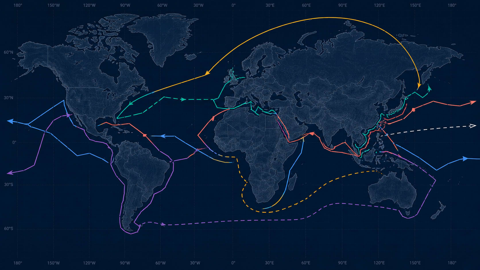
Think of the world's ocean surface the way an air traffic controller thinks of airspace. What looks like empty open water on the map is actually filled with invisible constraints: depth lines, pilotage zones, insurance boundaries, permit corridors, volcanic exclusion zones, and ice limits that shift with the season. The ten routes below are the places where those invisible constraints become visible enough to bend the line on the chart.
Some shipping routes look absurd on a map. The world's largest crude tankers can't use the world's busiest strait. A canal that saves a full day of steaming has been partially closed since a hillside collapsed. One of the deepest alternative straits in Southeast Asia has an active volcano in the middle of it. A shortcut through the Arctic is only open for ten weeks a year. And the straight line on every nautical chart is not, in fact, the shortest distance between two ports.
None of these are accidents. Each one is the product of physical constraint, regulatory design, geopolitical risk, or the economics of fuel, time, and cargo capacity. Here are ten of them.
1. Malacca Strait → Lombok Strait
The world's biggest ships can't use the world's busiest strait
The Strait of Malacca, between Malaysia, Singapore, and Indonesia, carries roughly 94,000 ship transits a year — more than 250 a day. About a quarter of global trade passes through it. It is the most commercially important waterway on the planet.
It is also only 25 metres deep at its shallowest point — with some sections as shallow as 23 metres.
A fully laden VLCC draws roughly 20 to 22 metres when loaded. Singapore's Maritime and Port Authority requires a minimum under-keel clearance of 3.5 metres for deep-draught vessels transiting the strait. The arithmetic is tight. The result is that most VLCCs either load to 80-90% of capacity to reduce draft and squeeze through, or they bypass Malacca entirely and take the Lombok Strait — a passage between Bali and Lombok with depths exceeding 250 metres.
The penalty for Lombok is roughly three extra days and 2,500 additional nautical miles on a round trip between the Middle East Gulf and Northeast Asia. The penalty for Malacca at partial load is $500,000 to $1 million in delayed cargo value per voyage. Every VLCC voyage planner in the world runs this calculation.
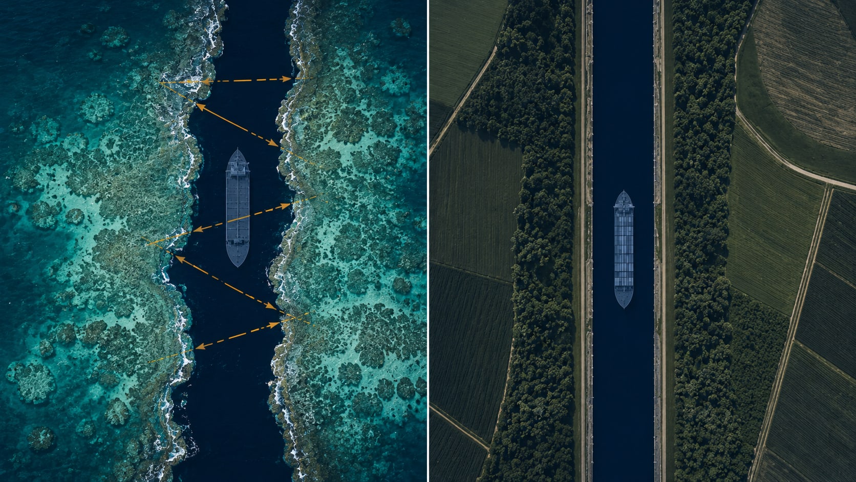
2. Sunda Strait
The shortcut with a volcano in the middle
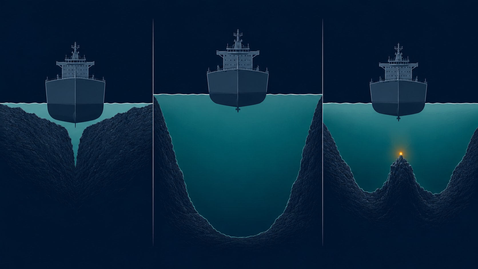
The Sunda Strait, between Java and Sumatra, is the other Malacca alternative. Its central channel depth of around 30 metres accommodates fully laden VLCCs, though the strait's overall depth varies and powerful tidal currents complicate navigation. It adds about 450 nautical miles and two to three days compared to Malacca — less than the Lombok detour.
In the middle of the Sunda Strait sits Anak Krakatoa, the volcanic island that emerged from the 1883 eruption of Krakatoa. It is an active volcano. Indonesian authorities maintain an exclusion zone around it. Eruptions can temporarily close the strait for 24 to 72 hours via ash clouds, tsunamis, and reduced visibility.
Routing VLCCs past an active volcano is the kind of decision that only makes sense in the language of marine economics. The volcanic hazard is calculated, insured, and accepted — because the alternative costs more.
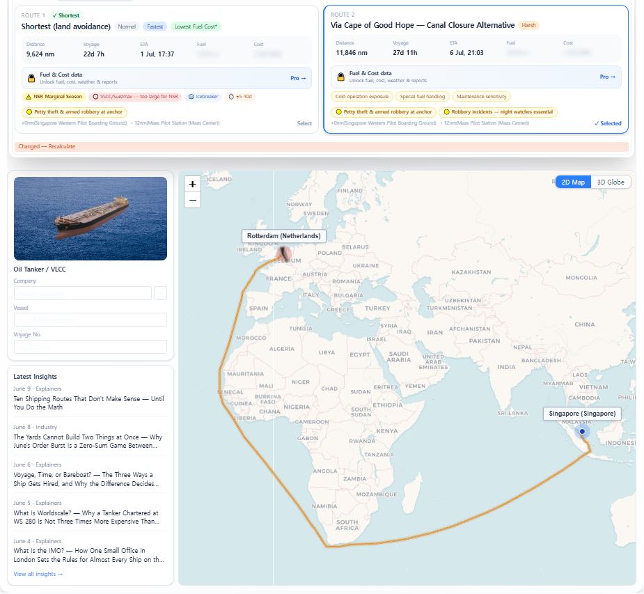
3. Cape of Good Hope
The fourteen-day detour that became the default again
When Houthi attacks on commercial shipping in the Red Sea and Bab-el-Mandeb strait escalated in late 2023, the world's largest container lines and tanker operators began rerouting around the Cape of Good Hope. The Cape adds approximately 3,500 nautical miles one-way (6,000 to 7,000 nautical miles round-trip) and 10 to 14 days to a Europe-bound voyage from the Middle East or Asia.
This was not new. The Suez Canal was physically closed from 1967 to 1975 during the Arab-Israeli conflicts, and the Cape was the default route for those eight years. The 2021 Ever Given grounding blocked Suez for six days and pushed more than 400 vessels to the Cape. The Cape has been the fallback for Suez disruptions for the entire modern shipping era. What changed after 2023 is that the rerouting persisted — the longest sustained commercial diversion since the 1967-1975 closure.
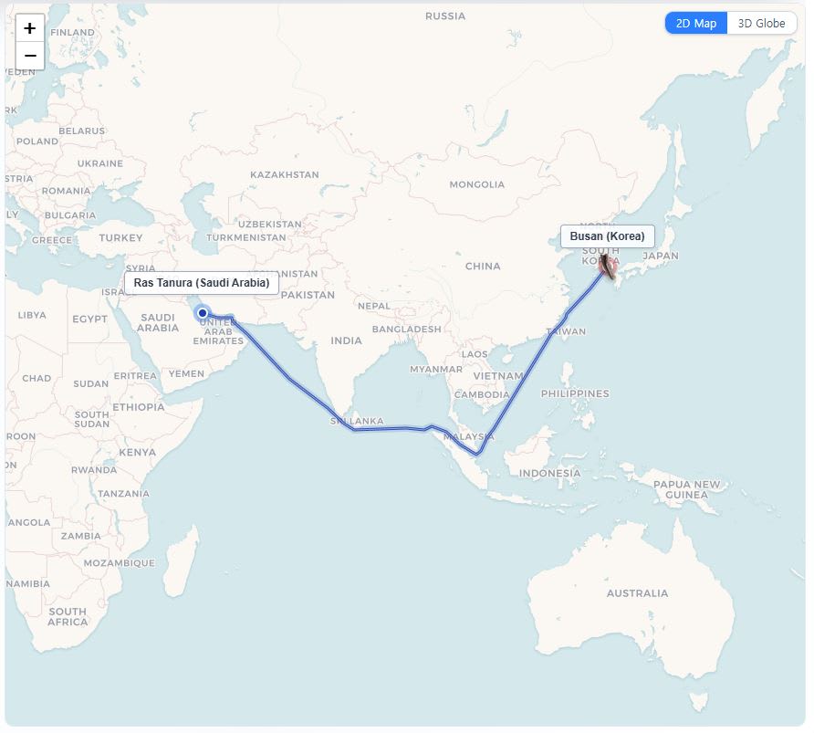
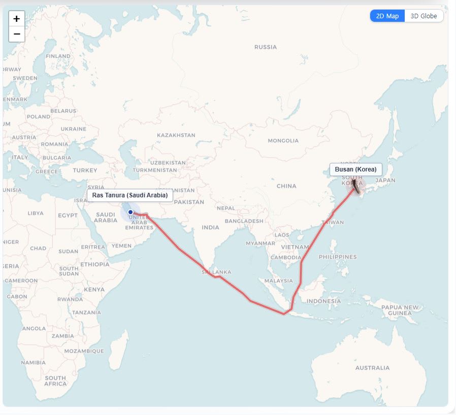
4. Strait of Hormuz → Fujairah bypass
The chokepoint that built its own workaround
The Strait of Hormuz carries roughly 20% of the world's crude oil supply. When tensions in the strait escalate, the commercial response is not just rerouting ships. It is rerouting the oil itself.
The Abu Dhabi Crude Oil Pipeline (ADCOP), completed in 2012, carries UAE crude from the Habshan oilfield to the port of Fujairah on the Gulf of Oman — bypassing the Strait of Hormuz entirely. The pipeline's design capacity is 1.5 million barrels per day, with maximum throughput of 1.8 million. In May 2026, the UAE directed ADNOC to accelerate construction of a second pipeline on the same corridor, targeting 2027 commissioning — which would double total bypass capacity to roughly 3 million barrels per day.
The pipeline exists because the chokepoint risk was judged severe enough to justify the infrastructure cost of never needing to transit Hormuz at all. Fujairah's bunker market, the third-largest in the world, sits on the far side of the chokepoint for the same reason.
5. Torres Strait
The reef, the current, and the compulsory pilot
The Torres Strait, between Australia and Papua New Guinea, is one of the most heavily regulated stretches of water in the world. It lies within the Great Barrier Reef Particularly Sensitive Sea Area, designated by the IMO in 1990.
Under Australian law, any vessel over 70 metres in length — and all loaded tankers, chemical carriers, and LNG carriers regardless of length — must carry a licensed pilot when transiting the Torres Strait. The penalty for transiting without a pilot: AUD 55,000 for the master and AUD 275,000 for the shipowner. The strait is 800 metres wide at its tightest point, subject to strong tidal currents that run across the channel rather than along it, and bounded by coral reefs on both sides. Many large bulk carriers and tankers choose to route south of Australia entirely rather than accept the navigational risk and pilotage cost.
6. Kiel Canal
Europe's hidden highway
The Kiel Canal runs 98 kilometres across the base of the Jutland Peninsula in northern Germany, connecting the North Sea to the Baltic Sea. It handles roughly 30,000 transits per year. For feeder container ships and smaller bulk carriers operating between Atlantic Europe and the Baltic, the canal saves approximately 460 nautical miles and two days compared to going around Denmark. Canal fees range from EUR 3,000 to 25,000 depending on vessel size. A delay at Kiel is cheaper than the fuel of going around. The canal is, for the northern European short-sea market, what the Suez Canal is for intercontinental trade — a toll that pays for itself in a single transit.
7. Corinth Canal
The canal that almost isn't
The Corinth Canal in Greece cuts across the isthmus connecting the Peloponnese to mainland Greece, saving approximately 185 nautical miles. It is 6.4 kilometres long and just 24.6 metres wide at water level. The canal has been under restricted operations since a series of landslides beginning in 2021 damaged its walls. Only vessels under approximately 16,000 DWT can transit. In practice, almost no commercial deep-sea vessel uses the Corinth Canal today. The canal exists as a geographic curiosity — a shortcut that is technically available but operationally irrelevant for most of the world's fleet.
8. Northern Sea Route
Open ten weeks. Closed the rest.
The Northern Sea Route runs along the Russian Arctic coast from the Barents Sea to the Bering Strait. The official Rosatom navigation season runs July 1 to November 30 — about five months — though the genuinely open-water window (without significant icebreaker support) typically lasts only six to ten weeks in late summer. The route cuts distance between Northern Europe and Northeast Asia by up to 40% compared to the Suez route. Transit requires a Rosatom permit, Russian icebreaker escort at roughly $15,000 per hour, and an ice-class-rated vessel. Summer transits cost approximately $120,000 each; autumn transits run closer to $210,000. Nearly all of the route's traffic is Russian domestic cargo — LNG from Yamal, crude from Arctic terminals — with around 103 transit voyages logged in the 2025 season. International transit-only traffic remains minimal. The route is a seasonal, permit-dependent, single-nation corridor.

9. Northwest Passage
The route that barely exists
The Northwest Passage through the Canadian Arctic Archipelago offers a dramatically shorter distance between Europe and Asia — in theory. In practice, it is navigable for only a few weeks each year, and even then only for ice-strengthened vessels. Canadian sovereignty claims are disputed by the US and the EU. There is no icebreaker escort service, no developed port infrastructure, and no commercial traffic to speak of. Climate projections suggest the passage may become seasonally ice-free by the 2040s or 2050s. Even if the ice melts on schedule, the infrastructure gap — ports, refuelling stations, ice-class pilots, search and rescue — would take another generation to close. The route exists on the map but not yet in the supply chain.
10. Great Circle vs Rhumb Line
The straight line is not the shortest distance
On a standard Mercator chart — the flat map projection that most nautical charts use — a straight line between two ports looks like the shortest route. It is not.
A rhumb line (a line of constant compass bearing) drawn on a Mercator chart is easy to steer but covers more distance than necessary. The actual shortest distance across the surface of a sphere is the great circle route — a curved line on a Mercator projection that initially looks longer but is 5 to 15% shorter depending on latitude and distance.
A voyage from Yokohama to the Panama Canal follows a great circle that arcs northeast toward the Aleutian Islands before curving back south — a path that looks absurd on a flat chart but saves hundreds of nautical miles. Every modern voyage planner calculates the great circle route first, then adjusts for weather, ice limits, ECA zones, and land obstructions.
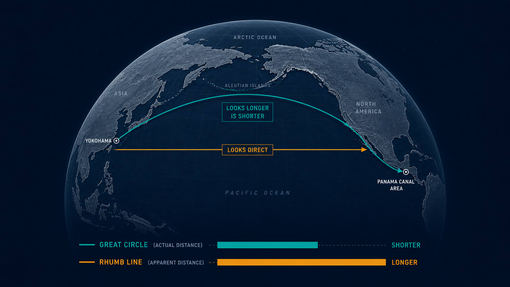
The "straight line" on the chart is the route nobody actually sails.
For route cost comparisons and voyage planning across these corridors, try the Fairway ETA Calculator. For more on the systems behind commercial routing, see our pieces on Suez vs Cape of Good Hope, Tanker Sizes Explained, and Ice Class Explained.